|

Constructing the Digital Terrain Model (DTM)
 The first step towards creating the real-time visual simulation model of the Herodian Temple Mount was to build the digital terrain. A topographical map of ancient Jerusalem (Relief Du Sol) defined the boundaries of the area to be modeled. This map was scanned and imported into MultiGen, the modeling program used by the Urban Simulation Team at UCLA to build three-dimensional geometry. Individual data layers were created for the topographical lines at 15-meter intervals and raised to their proper elevation.
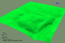
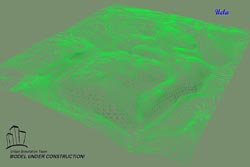 This 'stack' of data was used as the basis for a triangulated mesh surface model of the terrain. An aerial photograph of modern Jerusalem was then mapped onto the digital terrain model. A second map of ancient Jerusalem (Ben-Dov's) was digitized, composited with the topography map, and used to outline and extrude the ancient city walls. The digital terrain model (DTM) shown in the images below cover approximately 1 1/2 square miles of territory. In each image, Kidron Valley and Hinnom Valley are in the foreground. The Temple Mount will be built on Mount Moriah along the right hand side of the terrain. The first image shows the wireframe skeleton of the triangulated mesh surface. The second image shows the DTM with accentuated shading. The third shows the DTM combined with the aerial imagery.

|