|
|
|
|
|
|
|
|
|
|
|
|
|
| Home > Water systems > New Studies > Light at the End of the Tunel |
 |
Light at the End of the Tunel: Warren's Shaft Theory of David's Conquest Shattered
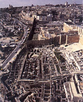
Ronny Reich and Eli Shukron, BAR January/February 1999: 22-33, 72Our tale begins on October 24, 1867, when Captain Charles Warren, of the London-based Palestine Exploration Fund, and his trusty assistant, Sergeant Birtles, crawled through the rock chamber where the water from the Gihon Spring collects, and climbed up a dark vertical rock shaft to investigate what lay at the top. They used a simple scaffolding made of wooden beams to ascend the shaft. When they reached the top, they were surprised to find themselves in a subterranean rock-cut passage mostly filled with debris and stones. Their short excavation was the first ever carried out in the City of David. "If this audacious attempt had been made in classical times," wrote the distinguished Jerusalem scholar Father Louis-Hugues Vincent, "it would certainly have been celebrated by an epic poem as important as that which sang of the heroic enterprise of Diomed and Ulysses when they stole the Palladium of Troy." Warren had discovered the water system since named for him, the Warren's Shaft System. A little more than 40 years later, between 1909 and 1911, Captain Montague B. Parker, a treasure-hunting son of an English earl who hoped to locate an underground tunnel to the Temple Mount, where he confidently expected to find the treasure of Solomon's Temple, also explored Warrens Shaft and discovered a series of other short tunnels around the Gihon Spring. Fortunately, Parker enlisted Father Vincent (whom we have already quoted) of the Ecole Biblique et Archeologique Francaise, to accompany him and record the results. A careful and responsible scholar, Vincent was invited to give this expedition a scientific air in order to mollify local criticism by both Arabs and Jews. Vincent took the job seriously. Although he did not make decisions about excavation strategy, he carefully recorded everything, most notably the rock-cut underground waterworks. Vincent's report, including plans and section drawings, is of extraordinary quality and continues to be very useful to this day. A consensus soon developed among scholars that the Warren's Shaft System (which includes Warren's Shaft and associated tunnels) was cut in the rock to provide safe access to the Gihon Spring without the risk of going outside the city's fortifications. Access to the Gihon Spring, Jerusalem's only natural water source, was essential for the survival of the early city residents. The system, which could be safely entered from inside the city walls, led underground to Warren's Shaft, which was used as an underground well. This water supply would be especially important if the city were under siege. The Warren's Shaft System consists of three principal parts: (1) a straight, steeply sloped tunnel with steps leading down to (2) a horizontal but sharply curved tunnel leading to (3) Warren's Shaft, a 40-foot-deep vertical rock chimney, the bottom of which was fed by a short underground tunnel from the Gihon Spring. Warren's Shaft was sidered to be the most ingenious ponent of the system. A bucket could supposedly be lowered from a rope to bring up the water. The question was soon raised as to whether the Warren's Shaft System was the means by which David's general Joab entered the city, surprising the Jebusites and enabling the Israelites to conquer it in about 1000 B.C.E. According to 2 Samuel 5:8, David said that "Whoever would strike down the Jebusites, let get up the tsinnor." The Hebrew term tsinnor is translated as "water shaft" in the New Revised Standard Version of the Bible. Scholarly debate focused on two issues: (1) The date of the system. Did it even exisr when David conquered the city? Or was it built later, in a period when underground water systems were thought to have been built at several other Israelite sites. (2) Was this subterranean passage the Biblical tsinnor? In the 1960s the British archaeologigst Kathleen Kenyon renewd excavations on the eastern slope of the City of David and uncovered the walls of the ancient city. Her findings confirmed that the Warren's Shaft System did indeed begin inside the city and, proceeding underground, ended outside the city wall. Between 1978 and 1985, the Israeli archaeologist Yigal Shiloh conducted the last major excavation in the City of David, paying particular attention to Warren's Shaft System. Shiloh's attempt to climb Warren's Shaft with the help of a rope ladder was as daring as Warren's own. He also cleared the entire system (which had been blocked since Parker's time) of debris and opened the system to the public. It is now one of the most popular tourist attractions in Jerusalem. Shilohs principal new conclusion, based mainly on the work of his geological consultant, Dan Gill, was that both the sloping tunnel and the horizontal tunnel were enlarged by man, but that the paths were fixed by nature. Scholars had long agreed about how the Jenisalemites drew water from the Gihon Spring. According to the traditional understanding-now under attack-an elaborate underground system of tunnels was dug (perhaps by the 10th or 9th century B.C.E.) to give residents of the city access to the Gihon Spring, downslope from the city. The entrance to the system, according to the old theory, lay inside the city walls. This entry chamber opened onto a steep, stepped tunnel, which led down to a gently inclined, but sharply curved tunnel that led to the top of Warren's Shaft. From here, buckets could be lowered down the shaft to draw water that collected 40 feet below in a lower tunnel leading from the Gihon Spring. But there are several flaws in the old theory: New excavations reveal that the system was not carved all at once. Further, Warren's Shaft was not part of the system as originally carved-and was never intended to be. Instead, the curved tunnel completely bypassed Warren's Shaft and continued through a cave that led to the newly discovered pool. The Warren's Shaft System, as it appears tday, was carved in two stages. In the Middle Bronze Age II (18th to 17th century B.C.E.), the original system was carved only in the soft Meleke limestone, which forms the top layer of bedrock throughout the City of David. Only centuries later (perhaps in the eighth century B.C.E.) was the horizontal tunnel deepened, perhaps to create a different route to the spring, by cutting into the lower layer of hard Mizzi Ahmar dolomite. Warren's Shaft was accidentally reached at this point, and the top of the shaft was widened; but the shaft was not the goal of the diggers. The shaft has too many protrusions for a bucket to be easily lowered down it, and the water that gathers at the bottom is too shallow to be captured efficiently in a bucket. These later tunnelers continued to deepen the tunnel even beyond the entrance to Warren's Shaft-further evidence that this was not their goal. Their work stops short a few feet east of the shaft entrance; perhaps they quit when Hezekiah's Tunnel, which brought water into the city, was cut in preparation for the Assyrian siege of 701 B.C.E Warren's Shaft itself was the result of natural dissolution. Continuous natural karstic fissures were the basis of the entire system, including the shaft. As for the date Shiloh concluded that the Warren's Shaft System was not cut until Iron Age II (1000-586 B.C.E.), after Jerusalem had become Israelite. So Warren's Shaft could not be the Biblical tsinnor. Shiloh based his dating, not onany pottery deposits (Warren and later Parker had cleared them all away, but on an analogy to other water systems - at Hazor and Megiddo, for example - that had been dated to the ninth to eighth century BCE. The area we are talking about - the eastern slope of the City of David and particularly the strip above the Gihon Spring - has been subject to more archaeological excavations and research than any site in Jerusalem, and even in Israel. The names of the researchers who have worked here read like a who's who of Biblical archaeology. We have already mentioned Warren, Parker and Vincent, Kenyon and Shiloh. To this list can be added Hermann Guthe, Conrad Schick, Reymond Weill, R.A.S. Macalister and J.G. Duncan, J.W. Crowfoot, and G.M. Fitzgerald. Strangely, tried to dig near the Gihon Spring itself. Excavations in the City of David were renewed in 1995 by the Israel Antiquities Authority (IAA) in connection with the celebration of the (approximately) 3000th anniversary of King David's capture of Jerusalem became the capital of Israel and the only place where the God of Israel was worshiped. Our assignment as archaeologists for the IAA was to complete excavation of a small area (actually of a corner at Shiloh's Area D1) that had been left unexcavated. Because we were on site, we were also asked to carry out some small nearby rescue digs. The Kidron Valley road was about to be repaved, so we excavated close to the south of the spring (our Area A). But then we received another assignment, in what we have designated Area C. The municipality had granted a construcrion permit for a Visitors' Center to be constructed next to the existing springhouse over the Gihon Spring. Before the center could be built, however, a rescue dig had to be completed. For the past two years, we have excavated south and west of the springhouse, and our work is not yet completed. To say that our findings are surprising is a gross understatement. Most of the eastern slope of the City of David above the Gihon Spring is covered by a very thick fill of debris, gravel and pottery sherds dumped here in the Second Temple period (mainly the first cenrury B.C.E. and the first century C.E.), when this area was on the city's periphery. This fill, which is about 25 feet thick, had been excavated fairly thoroughly by earlier investigators. But we still had to work through the fill in our area, all by manual labor, until we encountered, to our amazement, the remains of some monumental rock cuttings and construction. We decided to sink a deep probe. In our first attempt, we encountered the inner corner of huge masonry built adjacent to the spring on the southwest. We immediately recognized that we might well have discovered the remains of a tower built around the spring to protect it. If so, we had found the inside southwestern corner. Then in two small probes in front of the springhouse (our Area H, now temporarily recovered), we encountered the same type of masonry forming the outside corner of the structure. It was indeed a tower designed to protect the spring. And what a tower! The walls were more than 12 feet thick. On the outside, the rectangular tower measured 45 by 55 feet. What was most impressive, however, was the masonry with which the tower was built: huge blocks-we call them cyclopean-of undressed and only slightly worked stones that survived in places up to four courses. Some of these stones are nearly 6 feet long, 3 feet high and 3 feet deep. Not until Herodian times (first century B.C.E.) do we again find such huge masonry (and even larger) in Jerusalem. This tower-the Spring Tower, as we call it to distinguish it from another tower (and perhaps rwo other towers)-was part of a large, complex water system that promised the residents of Jerusalem a secure supply of water. The area within the tower, where the spring was located, would have filled up with water in seconds unless there were some exit for the springwater, which emerges from a crevice in the rock. We discovered a large conduit cut into the rock, which channeled the water out of the Spring Tower. This extends all the way down the eastern side of the City of David, where it debouches into pools at the southern end of the city. We call this Channel II because that is the designation Louis- Hugues Vincent used on his meticulous plans when the Parker mission discovered part of the channel. This water conduit is correctly called a channel, rather than a tunnel, because it is cut in the rock from the ground surface. In the Spring Tower, Channel II is more than 15 feet deep and between 1.5 and 3 feet wide. It was nevertheless carefully secured fromabove with huge boulders weighing up to rwo tons rather than with simple flat cover stones. The upper pan of the channel was slightly V-shaped, so when these boulders were thrown into the channel, they stuck in the V and sealed off the channel. Since they were quite huge, it would not have been easy to remove them. Below the boulders remained a 6- to 12- foot-deep channel through which water could flow in security. About 20 feet from the beginning of Channel II, a subsidiary rock-cut tunnel (Vincent's Tunnel III) leads to the west into a large, deep rectangular rock-cut pool. So far, only a small part of the 22- by 10-foot pool has been cleared, as it reaches beyond our excavation's limits and runs below the concrete foundation of the new Visitors' Center and an adjacent house, which would be endangered by further digging. Adjacent to the pool on the north, we discovered the foundations of another gigantic tower, which we call the Pool Tower. The southern rock-cur base of this tower is vertical and is at the same time the northern side of the pool. This smoothly chiseled face, which tilts slightly toward the pool, is nearly 30 feet high. Above the rock-cut base were two thick parallel walls (about 10 feet ide)built in an east-west direction, made of cyclopean masonry similar to the masonry of the Spring Tower. These walls were all part of a tower north of the pool. We assume that a similar tower was built on the south side of the pool, but confirmation must await further excavation. Horizontal grooves are chiseled into the rock face of the pool. Wooden.platforms were probably inserted into these grooves so that several people could easily draw water from the pool simultaneously. When was this impressive complex constructed? And how long did it provide access to the city's water supply? Especially intriguing: Was it in use when King David conquered the city in about 1000 B.C.E.? On the stone-riled floor of the Pool Tower and within small crevices between the huge stone blocks of the Spring Tower, we recovered potsherds from a single period-Middle Bronze II (18th and 17th centuries B.C.E.). Similar sherds were found in the towers between the rock-cut bases and the lowest course of stones. These sherds must have been deposited here very close to the date of construction. In her City of David excavation in the 1960s, Kathleen Kenyon. uncovered a 40- foot stretch of a thick city wall higher up on the slope. She dated the walls in the same way-by examining the potsherds in the foundation trench of the wall. These, too, dared to Middle Bronze II. A 240-foot stretch of this same wall was excavated by Yigal Shiloh (in his Area E), and he also confirmed this dating. For the sake of historical, we must note that Parker and Vincent were actually the first to expose a section of this Middle Bronze II city wall, although their discovery was either ignored or missed by Kenyon. Apparently the tower fortifications that we uncovered (and the city wall excavated higher up on the slope) were all part of a defensive plan for the city constructed sometime in the 18th to 17th century B.C.E. This dating is consistent with similar finds at Gezer, Tel Balata (Shechem) and Hebron (Tell Rumeida). At each of these sites, cyclopean structures with huge stones and rock-cut foundations have been excavated and dated to Middle Bronze II. For allthese reasons, we feel secure in our dating. What about the date of Channel II, which leads from the Spring Tower to the pool? Water channels are notoriously difficult to date. Pottery found in them is usually of little or no significance; sherds may have entered either from strata that existed before the channel was constructed (having washed down the hill) or at any time after construction. In the case of Channel II, however, we were fortunate. The southern wall of the Spring Tower was built over the cover stones of Channel II. That means that Channel II must have been constructed before the Spring Tower, which we have dated. Channel II was probably built just before the tower, as part of the same complex, and thus dates to Middle Bronze II. We can also tell when the system probably went out of use. In some areas, we found the fortifications covered with a large amount of pottery from the eighth to seventh century B.C.E., which indicates this was the last time the complex was visible and, perhaps, the last time it was in use. With these preliminary results of our excavation, we returned to the Warren's Shaft System to see if we could understand it better in light of our discoveries. Our most surprising discovery was that it was dug in two phases-with an interval of about a thousand years in between. Since Shiloh completed his excavation, visitors have been able to descend the underground tunnel of the water system to a point facing the top of Warren's Shaft. It is dangerous-and forbidden-to follow the tunnel beyond this point. Visitors must then retrace their steps and climb back up to the entrance. Just beyond Warren's Shaft, however, are two natural caves (or perhaps one continuous cave). Shiloh ignored these caves, apparently because he supposed that he understood how the Warren's Shaft System operated. Access to the caves, just beyond the top of the shaft, is not easy. To enter them requires a 10-foot climb up from the opening of the shaft. Parker and Vincent, however, did explore these caves, crawling in them near the ceiling. Inside, we found several of their rusted buckets and a pipe! But neither really excavated the caves, although Parker did discover a horizontal exit from one of the caves leading out to the side of the hill. We excavated a long, narrow section, or probe, in the southern cave from ceiling to rock floor, only to discover that it had initially served as a dwelling in the Early Bronze Age I (c. 2900 B.C.E.), as attested by a layer of pottery from this period on the cave floor. This cave also produced evidence that Warren's Shaft System had been dug in two phases at two different times. But more about the evidence from this cave later. As observed by Shiloh's geologist, Dan Gill (and by Vincent before him), the Warren's Shaft System was dug out of two layers of rock: an upper layer of soft white Meleke rock and a lower layer of very hard reddish Mizzi stone. Everyone has always assumed that the tunnel leading to the shaft was dug at one time; the purpose of the tunnel, all agreed, was to provide safe access to Warren's Shaft and the waters of the Gihon Spring. The discovery of the Spring Tower and the rock-cut pool, however, suggests that access to Warren's Shaft was not really the goal of the tunnel system. We propose a different scenario regarding the construction of the tunnel. Initially an underground tunnel was cut only in the soft Meleke rock. The hard Mizzi rock layer below served as the floor of the horizontal tunnel. This tunnel connected the inner part of the city with the cave beyond Warren's Shaft and with the adjacent tower and pool that we recently discovered. This tunnel, which had a sloping stepped section and a horizontal section, was cut by two gangs of cutters working from both sides. Their meeting point can clearly be seen where the sloping tunnel and the horizontal tunnel meet. The upper gang started at the entrance to the system within the city wall; the lower gang entered from the side of the hill into the natural cave and followed a horizontal curving line up to the point where they met the other gang. However, these diggers did not even know about Warren's Shaft. Warren's Shaft was not visible to them because it is located entirely in the hard Mizzi rock. Its top is nearly 4 feet lower than the upper edge of the hard rock layer, as can be clearly seen today. Since the cutters of the system at this stage were unaware of Warren's Shaft, they could not aim toward it. It seems logical, however, that the tunnels they dug were part of the same complex as the Spring Tower and its adjacent rock-cut pool, which we have dated to the Middle Bronze Age II. We recently opened the final 20 feet from the underground tunnel to the pool, so there is now no doubt that the tunnel aimed at the pool! We are now working on a project to open the entire system to the public (the section already open to tourists as well as the newly excavated part). This work requires a continuous process of supporting the rock with steel scaffolding, all done for us by the IAA's Department of Conservation of Monuments. Long after the tunnels were initially cut, it was decided to deepen the horizontal tunnel by cutting into the hard rock floor, that is, to cut into the hard Mizzi rock. Until that rime, the horizontal tunnel was about 10 feet high, similar to the height of the sloping tunnel. By cutting into the hard rock floor, the horizontal tunnel was gradually deepened to more than double its previous height. Only at that point was Warren's Shaft, a natural vertical dissolution fissure entirely located in the hard rock, discovered. The discovery of Warren's Shaft was entirely accidental. Proof of this comes from the fact that the deepened horizontal tunnel was cut to about 3 feet beyond the top of Warren's Shaft. They would never have done this if the shaft was their goal. And Warren's Shaft was never used to draw water. This should have been obvious to us all along because it is extremely difficult, if not impossible, to draw water through it. Not only is it difficult to stand at the edge (although some wooden stand could have been constructed), but the shaft itself is filled with protrusions that make it very difficult to lower and lift up a bucket. After expending enormous energy to double the height of the horizontal shaft to 20 feet, why wouldn't the cutters take the little extra effort to remove the protrusions from the shaft and straighten it to enable the convenient drawing of water-if indeed that was their goal? To be sure that we were correct-that Warren's Shaft was never used to draw water, we recently remeasured the shaft and found that the bottom, where the water of the spring collected, was not deep enough to allow a bucket dropped from above to sink conveniently into the water and be filled. We can tell when this second phase of cutting occurred. The evidence lies in the cave that was home to a family in the Early Bronze Age I and that, later (in the Middle Bronze Age II), was the exit of the system leading to the rock-cut pool. We recovered the cutting waste from the cave floor. Above the Early Bronze Age I deposit on the floor of the cave was a layer, almost a foot and a half thick, of stone chips, which covered the entire cave. When the cutters deepened the horizontal tunnel, they hauled the debris into this cave and then out through the opening on the side of the hill, where they dumped it. The chips left in the cave fell off during this process. All of these stone chips are of hard Mizzi ston. Not a single stone chip comes from the softer Meleke of the upper level. This clearly indicates that the system was cut in two phases. The first phase cut into the soft rock; the entire waste was cleared away. Leaving behind not a single stone chip, in the first phase. The system was used for centuries to get to the Spring Tower. Periodically the system would need cleaning, and in the course of so doing, all the cutting waste from digging through the soft Meleke was removed. The second phase of cutting was interrupted not long after it began, so all the waste on the cave floor is still there. We have a pretty good idea when the second phase was cut, and we know why it was probably abandoned but we don't know why it was undertaken. Perhaps it was part of an effort to create a different approach to the spring. In any event, mixed with the stone chips from the second-phase cutting were pottery sherds from oil lamps easily dated to the eighth century BCE. That is probably when the second phase was undertaken. This eighth century BCE pottery was found not only on parts of the fortification walls, in the pool and in the channel leading to it. This indicated that the system was still in use in the eighth century BCE at which time it was abandoned. The presence of the hard stone chips also that the second phase was never completed and that the deepened horizontal tunnel was never used` that's why the stone chips were left lying around. Why it was abandoned remains conjecture. Our best guess is that the entire system was abandoned at this time because a much more efficient system was created: Hezekiah's Tunnel, dug in the late eighth century BCE carried the water of the Gihon spring through a nearly 1500-foottunnel to a protected location on the far (western) side of the city. The Warren's Shaft System was no longer needed. Whether any part of this water system may be associated with the tzinnor reffered to in the Bible, we leave to others. The dating of the system - the Middle Bronze II period (c. 1800-1600 BCE) - provides no obsticle. Did David's men (Joab himself?) somehow get into this system through the channel from the pool to the cave and from there into the horizontal and sloping stepped tunnels! We do not know. What is clear, however, is that Warren's Shaft was not part of the plan. If this new understanding makes it easier for Joab - or more difficult - to get into the city, so be it. |