|
|
|
|
|
|
|
|
|
|
|
|
|
| Home > Water systems > New Studies > Jerusalem, City of David |
 |
Jerusalem, City of David
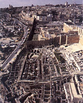
Ronny Reich and Eli Shukron, Hadashot Arkheologiyot-Excavations and Surveys in Israel 115:51*-53*During 2002, excavations were conducted in Area C-the Gihon spring (HA-ESI 114) and in Area E-Warren's Shaft (ESI 20:99*-100*). The excavations, on behalf of the Antiquities Authority and financed by the El'ad Association and the Organization for the Promotion of Trade Israel-Netherlands (OPTIN), were directed by R. Reich and E. Shukron, assisted by V. Essman, V. Pirsky and T. Kornfeld (surveying and drafting), and G. Laron (field photography). AREA C The Rock-Cut Pool, in the southern part of the area, was cleaned of a large amount of soil that the winter rains had washed in. The pool's northern wall was exposed to its full height (c. 14 m), as well as substantial sections of its western and eastern walls. The pool's southern wall was detected in a trial probe. Once the four walls were revealed the pool's dimensions became apparent (c. 10 � 15 m). Midway up the pool, the southern end of what was probably a stepped, rock-hewn passageway (width 1.4 m) that descended to the pool from south to north, was uncovered. At the end of the passageway was a hewn step. The eastern wall of the passageway was the continuation of the pool's eastern wall and it therefore seems that the passageway was hewn when the pool was originally quarried. The lower part of the pool was referred to in Parker's excavation as the 'Round Chamber'. It was entirely cleared and it turned out that the shape of the chamber was 'L'-shaped and not circular, as described by Parker. The northeastern corner of the room was in fact, the very beginning of a tunnel quarried to the north; it made use of a vertical fissure in the bedrock that ran up to surface. The quarrying was suspended after less than a meter of rock was removed. Next to the northwestern corner of the pool's lower part was the opening of Tunnel IV, which connected to Hezekiah's Tunnel. The pool's floor was swept out and it became evident that the pool was hewn in an extremely coarse manner. The water at the deepest location in the pool reached a depth of c. 1.4 m, in accordance with the water level in Channel II that fed the pool. The Spring Tower. The top of the eastern side of the Spring Tower was exposed. A limited trial excavation was conducted in the easternmost part of the area, which was also the easternmost place that had been excavated to date in the Nahal Qidron bed. A small wall segment (width c. 2 m) oriented north-south and built of small fieldstones was discerned. The excavation along the eastern face of the wall reached a depth of c. 6 m, where the wall was preserved to its full height. The earth that accumulated along the eastern face of the wall contained ceramic finds from the end of the Second Temple period and it was the bottom of a large refuse dump from this period that covered the entire eastern hillside of the City of David. The area on the western side of the wall had only been excavated to a shallow depth, to date. Nevertheless, it was already obvious that the earth on this side contained only pottery fragments from Iron Age II, the period when the wall was used and perhaps built as well. Some 120 m to the south of here, in Area J, three parallel walls that had previously been discovered were dated to the end of Iron Age II (HA-ESI 113). The eastern one of these walls most resembled the wall segment that was found here, in its location toward the foot of the slope, its level, direction, manner of construction and date. In all likelihood, the wall segment was the continuation of the wall to its south. The Spring House. The space below the bottom staircase of the Spring House was cleared. The inner, northern face of the Spring Tower's southern wall was cleaned; it was ascertained that the wall, built of very large stones, widened toward its bottom (bottom width c. 7 m). A narrow passageway, dating to the end of the Second Temple period, breached the narrow top of the wall; the passageway led to the fortified cell of Middle Bronze II tower, within which the spring derived. The Spring House is built today atop the fortified cell, allowing access to the spring from the open area above by way of two staircases. Excavations of the space below the bottom staircase were conducted at the end of the 19th century by Schick and Masterman and in the beginning of the 20th century by Parker and Vincent. Almost the entire space was filled with earth that contained modern refuse. A strip of soil that had not been disturbed in the previous excavations remained along the eastern wall of the fortified cell, close to the inner face of the Spring Tower's eastern wall. It contained clay and fragments of pottery vessels from the Roman period, the time when the cell filled up with alluvium after it was no longer in use, following the destruction of the Second Temple. The removal of soil revealed the details that Vincent documented, as well as additional information that was unknown until now. A finely built entrance (width 0.8 m) constructed from ashlars was noted in the narrow passageway that led to the fortified cell. A door socket was in the entrance's threshold and also an iron 'sandal' that protected the most certainly wooden post. The door opened to the north, into the fortified cell, which contained the remains of a stone staircase, descending westward toward the water. It became apparent that during the Second Temple period care was taken to build a proper entrance to the site that was the source for the Gihon spring. It also turned out that on the eastern side of the space below the Spring House the western, inner face of the Spring Tower's eastern wall, which was built of very large stones, among them a stone c. 3.2 m long, was c. 7 m wide and stood exposed. The eastern, outer face of this wall was known, as well as its two outer, eastern corners. This is the widest and most massive wall ever recorded in Jerusalem that predates the Herodian period. It seems that the wall was constructed in such a manner so as to overcome Nahal Qidron's capacity to undermine and erode during the wintertime. The fortified cell was bisected by two north-south walls (Walls I and J according to Vincent). Wall I closed off the cell on the west and prevented water from entering into it. The end of Channel I was at the bottom of the cell. This channel was narrow, low and rather windy, and did not allow easy movement in it. Its northern part was cut into bedrock and its continuation was built mostly on bedrock and covered over with stone slabs. The channel was plastered in connection with Schick or Parker's activities. The channel continued southward and had previously been excavated by the authors in Area J, where it was dated to Iron Age II by the ceramics found associated with its foundations, which were built on bedrock. AREA E The Warren's Shaft system was emptied out of earth and sacks of soil that remained there from previous excavations, disclosing new details. Two adjacent caves, whose entrances faced east existed before the underground water system was hewn. The bottom group of rock cutters that was hewing the Warren's Shaft system began quarrying from these caves, which were completely cleaned out together with the system. The westernmost part of the Pool Tower's thick, northern wall was also traced. It rested on the fringes of the caves and was partially inside them, the southern face in the southern cave and the northern face in the northern cave. The Pool Tower's inner cell, which was blocked up with an intentional fill of fieldstones and earth, was cleared as well; the eastern part of the cell is visible in the visitors' center. The fill terminated inside the southern cave, at the inclined retaining wall that extended between the two walls of the Pool Tower. It became evident that Parker removed part of the intentional fill and thus, we could understand its structure. It contained several potsherds from the end of Iron Age II that were indicative of the time when the gap was blocked between the walls of the Pool Tower. Rock Cutting L (according to Vincent), in the western wall of the southern cave, was entirely excavated. It was the beginning of a tunnel (width c. 2.55-2.85 m) hewn in a westerly direction. The quarrying was suspended after c. 4.5 m. This quarrying was aimed toward the bottom of the 'Unfinished Shaft' ('The Trial Shaft') that the Parker expedition uncovered. Probably both of these rock cuttings, Rock Cutting 'L' and the 'Unfinished Shaft', were the first endeavor to connect the inside of the city with the area of the spring, an attempt that was probably abandoned due to the precipitous route. The tunnel that was ultimately hewn for the Warren's Shaft system was longer because it made a wide turn to the north and east but one could still walk through it comfortably. It was also apparent that Rock Cutting L was located exactly opposite the gap between the two walls of the Spring Tower and was aligned with the tower, attesting to the chronological association between them. The earth and bags of soil on bedrock surface above Warren's Shaft were removed, revealing sections of a crushed and beaten chalk floor. This floor abutted the northern wall of the Pool Tower, which was inserted into the entrance of the northern cave. A wall of small fieldstones that blocked the cave's entrance was built on the floor. The northern cave contained a group of mud loom weights, in situ; such weights, many of which were discovered in the City of David, were characteristic of Iron Age II. Near the weights a smudge of charred wood, ash and fragments of more loom weights were detected. It was surprising that the group of loom weights was preserved in situ since their location was excavated and examined in the past. The loom weights and beaten chalk floor were covered with a thick layer of small stone chips that derived from the quarrying of a hard bedrock layer, when the Warren's Shaft system was made deeper. The loom weights indicated that at the end of Iron Age II the place ceased to be used as a public underground water system and was taken over by private individuals, who were engaged in weaving. Nonetheless, an attempt to reconvert the site into a public water system was made, when the previous water system's horizontal tunnel was deepened by gradually hewing away at the hard bedrock. Judging by the recovered ceramic finds from the deepening of the tunnel, the conversion occurred in the 8th century BCE. |