|
|
|

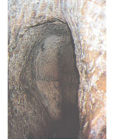
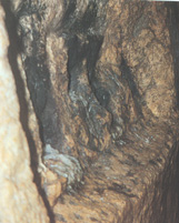
Hezekiah's Tunnel
|
This tunnel is about 533 meters long. It is fairly narrow (average width c. 60 cm), and of variable height: in the central part it is only about a meter and a half high, but near the south exit its height reaches some five meters. At first the tunnel runs a straight course; it then veers to the south (the left) in a broad arch and proceeds along a winding course, somewhat like the letter 'S'. Rock-cutting marks are clearly visible on the tunnel walls. The south end of the tunnel opens onto the Pool of Siloam in the south of the City of David. |
|
From as early as the nineteenth century it had been an accepted view that this tunnel was cut under Hezekiah, King of Judah, as part of his preparations against an anticipated Assyrian invasion(around 700 BCE). It probably replaced the water system known as Channel II. According to biblical sources (see 2 kings 20:20; Isaiah 22:9-11; 2 Chronicles) the tunnel was constructed in order to lead water from the Gihon Spring, which is located outside the city walls, to the Siloam Pool, located within the boundaries of the city during this period. |
|
Robinson and Smith were the first to investigate Hezekiah's Tunnel (1838) and identify its ending at the Siloam Pool. Later investigators were Herman and Guthe (1881) and Dickie (1894-1897). Warren measured the tunnel (1866) and Parker's expedition cleaned it (1909-1911). At the same time Vincent ventured to sketch it; his sketches are still in use today. In 1923-1924 Weill excavated yet another channel at the southern end of the City of David (Channel IV). This channel is most likely the southern extension of the Siloam Tunnel, which ended in the Siloam Pool, originally located south of today's (Roman) Siloam Pool This theory suggests that the Siloam Inscription, discovered in the late nineteenth century and published by Clermont-Ganneau, was located at a distance from the tunnel's exit. Interactive Map |

|