|
|
|
|
|
|
|
|
|
|
|
|
|
| Home > Virtual Reconstruction Model > Using Photography to Define Platform/Texture Mapping |
|
Using Photography to Define Platform/Texture Mapping
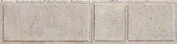
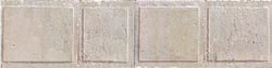
Digital images played an important role in the construction of the Herodian Temple Mount real-time visual simulation model. During a site visit in April of 1999, Urban Simulation Team modeler Lisa M. Snyder took over 900 images of the excavations with a digital camera. The images were initially used as a guide during the construction of the model's geometry. Later, they were used as source material for texture maps (two-dimensional images mapped onto the model's surface geometry to give form and detail to the objects). As of January 1, 2001, the Herodian Temple Mount model contained 1,175,847 individual triangles, each texture mapped with one of 301 different textures.
Texture map creation and reconstruction are discussed in greater length in the following pages.
|